Reims Cessna F.150M G-BFRP, crashed on Broadlee Bank Tor near Edale on the 25th October 1983
| Barry Bryant | Mr | Pilot (Instructor) | OK |
| John Bateson | Mr | Pilot (Pupil) | OK |
The aircraft was being used for a night training flight from Manchester Airport with a student pilot and an instructor onboard. Most of the planned flight had been accomplished and the pair were returning to Manchester Airport under VFR but with guidance from Manchester Approach Radar. At 19:16 the aircraft was about 17 miles southeast of Manchester and at this time received permission to enter the controlled airspace around the airport on a northerly heading. For ten minutes the instructor flew this course, but unknown to him was actually on a course of 036o as the aircraft was crabbing in a strong westerly air flow. At 19:26 a conversation with the approach controller took place with the pilot being instructed to fly a left hand orbit to increase separation from other traffic.
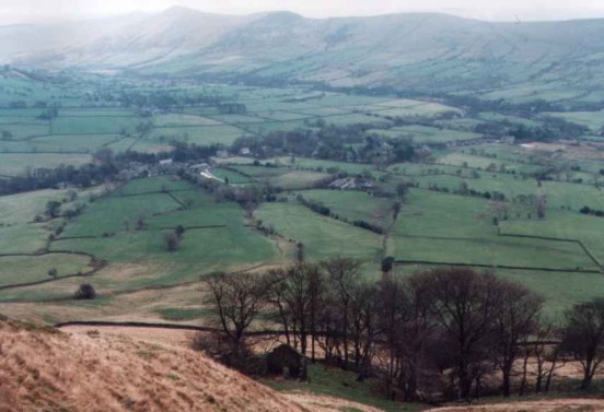
It was during this obit the controller observed the radar return and advised the pilot that he seemed to be being affected by the wind and gave him a course of 320o to reduce the effect. At this time the Cessna was to the east of Buxton, which the instructor reported he could the street lights of. At 19:33, while 14.5 miles from the airport, a new heading of 300o was passed to the aircraft to bring it on to the runway centreline at a range of 7 to 8 miles from the airport. When this course change was requested the aircraft was about 1 mile north east of Edale at 3,000ft.
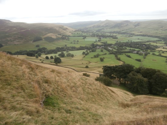
The course change brought the aircraft almost head on into the wind, so it was no longer being blown off course, however being on the leeward side of Kinder meant that the aircraft was being subjected to a strong downdraught. About one and a half minutes after changing to 300o the controller instructed the pilot to take up a course of 280o which was acknowledged after 30 seconds with the pilot also stating that the aircraft was in a strong downdraught and was unable to maintain height. The approach controller told the pilot to resume his own navigation of the aircraft so that they could avoid the high ground. After another 30 seconds the pilot declared an emergency reporting that the aircraft was descending at 1000 feet per minute.

The engine was set to full power and the air speed was indicating the appropriate speed for climbing but the aircraft continued to fall. Seeing the outline of the high ground approaching in the darkness the instructor reduced the aircraft’s speed to between 55 and 65mph knowing that they were going to crash. The aircraft struck the upper slope of Broadlee Bank Tor above Edale at 1,650ft and turned over falling a short way back down the hill with the engine breaking off and the tail broke off. Both men while bruised and shaken were not seriously injured and were able to escape the wrecked aircraft.

